$4.36
Original: $14.54
-70%Hesquiat Peninsula Map—
$14.54
$4.36The Story
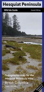
The Hesquiat Peninsula is a west coast promontory of Vancouver Island and divides Clayoquot and Nootka Sounds. The topography of the peninsula is comprised of a low, flat swampy forest rimmed with a stunning geologically diverse shoreline.
The shape of the peninsula is square cut with a long stretch of rocky shoreline running north-south from Burdwood Point, at the entrance to Nootka Sound, to the historic lighthouse at Estevan Point. From Estevan Point the coast turns abruptly 90 degrees west-east across to Smokehouse Bay. At the east end of Smokehouse Bay the shore swings another right angle south-north from Matlahaw Point past Hesquiat village and a series of immense beaches to Boat Basin at the head of Hesquiat Harbour.
Much of the land on the Hesquiat Peninsula is now Provincial Park, from Escalante Point all the way around to Hot Springs Cove which is part of Maquinna Marine Park. This region is ancestral home of the Hesquiat First Nation, of the west coast Nuu-chah-nulth people, and there are residents at the tiny outpost of Hesquiat Village. Points of interest along the route include the beaches at Escalante, Estevan Point lighthouse, Hesquiat Village, beaches around Anton’s Spit and Cougar Annie’s Garden in Boat Basin.
Description
The Hesquiat Peninsula is a west coast promontory of Vancouver Island and divides Clayoquot and Nootka Sounds. The topography of the peninsula is comprised of a low, flat swampy forest rimmed with a stunning geologically diverse shoreline.
The shape of the peninsula is square cut with a long stretch of rocky shoreline running north-south from Burdwood Point, at the entrance to Nootka Sound, to the historic lighthouse at Estevan Point. From Estevan Point the coast turns abruptly 90 degrees west-east across to Smokehouse Bay. At the east end of Smokehouse Bay the shore swings another right angle south-north from Matlahaw Point past Hesquiat village and a series of immense beaches to Boat Basin at the head of Hesquiat Harbour.
Much of the land on the Hesquiat Peninsula is now Provincial Park, from Escalante Point all the way around to Hot Springs Cove which is part of Maquinna Marine Park. This region is ancestral home of the Hesquiat First Nation, of the west coast Nuu-chah-nulth people, and there are residents at the tiny outpost of Hesquiat Village. Points of interest along the route include the beaches at Escalante, Estevan Point lighthouse, Hesquiat Village, beaches around Anton’s Spit and Cougar Annie’s Garden in Boat Basin.
The shape of the peninsula is square cut with a long stretch of rocky shoreline running north-south from Burdwood Point, at the entrance to Nootka Sound, to the historic lighthouse at Estevan Point. From Estevan Point the coast turns abruptly 90 degrees west-east across to Smokehouse Bay. At the east end of Smokehouse Bay the shore swings another right angle south-north from Matlahaw Point past Hesquiat village and a series of immense beaches to Boat Basin at the head of Hesquiat Harbour.
Much of the land on the Hesquiat Peninsula is now Provincial Park, from Escalante Point all the way around to Hot Springs Cove which is part of Maquinna Marine Park. This region is ancestral home of the Hesquiat First Nation, of the west coast Nuu-chah-nulth people, and there are residents at the tiny outpost of Hesquiat Village. Points of interest along the route include the beaches at Escalante, Estevan Point lighthouse, Hesquiat Village, beaches around Anton’s Spit and Cougar Annie’s Garden in Boat Basin.